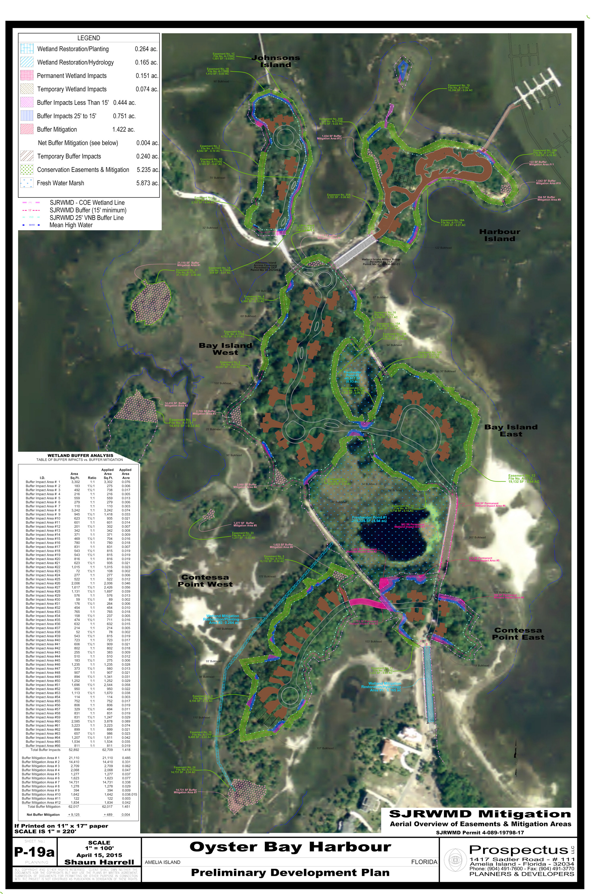
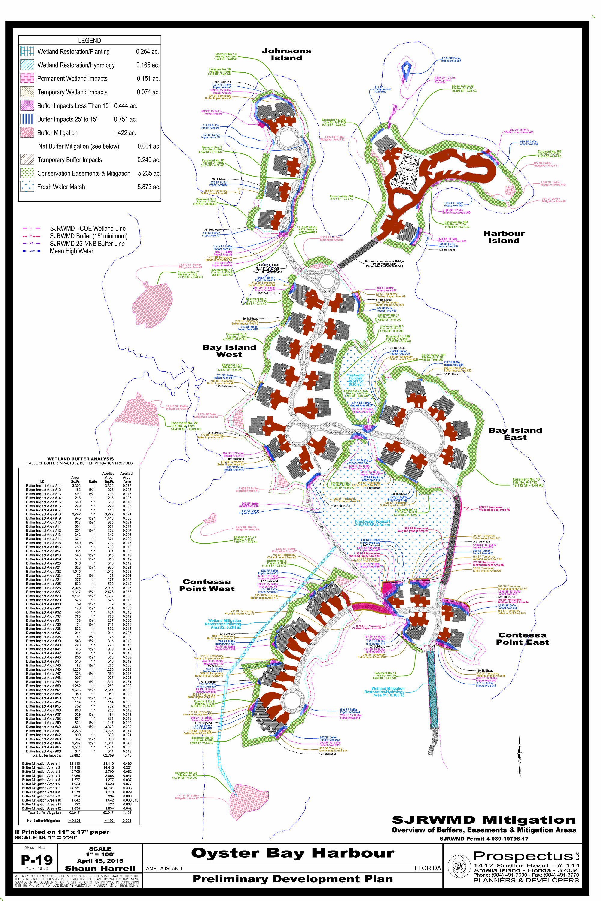
Prospectus has achieved an historic milestone with the St. John River Water Management District (SJRWMD) approval of the Environmental Resource Permit (40-089-19798-17 ) for Oyster Bay Harbours. The SJRWMD rules require a 25-foot buffer along all wetlands be kept in it natural condition. The buffer is designed to address ‘secondary and cumulative’ impacts to the wetland caused by development near the wetlands. The buffer allows existing transitional vegetation to remain undisturbed, which helps filter pollution. The continuous buffer also offers a path for critters to move and forage near the wetlands.
Unfortunately, these buffers usually don’t work well over the long run. Once residents take position of their lot, grasses planted in the backyards choke-out the transitional fauna. Residents are also reluctant to share their yard with snakes, raccoons, armadillos and similar wildlife. Often, in defiance of SJRWMD rules, fences are erected in the buffers. The fill dirt that is used to elevate the home above the floodplain often erodes into the buffer and raises their elevation. The higher rear yard also forces increased rainfall runoff into the buffers. Combining the increased runoff with erosion of fill-dirt into the buffers, impacts the transitional wetland fauna. Over the long run, these well-intentioned wetland buffers fail.
Working with SJRWMD environmental scientist, Prospectus proposed an alternative strategy. We proposed creating larger undisturbed wetland areas not located on individual lots. These larger upland pockets are permanently protected with conservation easements that are the responsibility of the homeowner association (HOA.) Removing the ownership from individuals in favor of the HOA permanently protects the habitat for wetland fauna and wildlife. Also, the larger areas are more sustainable and offer viable habitat. Once the SJRWMD was receptive to the concept, the real work started.
Prospectus compiled a detailed assessment of the area that would be created by a 25-foot buffer. Quantifying the area required by the existing rules established a baseline to compare to the final plan. The SJRWMD actual rule is: a 25-foot average wetland buffer with a minimum buffer of 15-foot along the Jurisdictional Wetland Line. We proposed to encroach within the minimum 15-foot buffer however; we would provide a ‘penalty’ for that encroachment. For every square foot of encroachment within the 15-foot minimum buffer, one and half square feet of buffer would be created. So the assessment also mandated determining the 15-foot minimum buffer areas required.
After establishing all of the required areas, Prospectus developed a master plan of the project that yielded 84-lots. We also established 31 separate Wetland Buffer areas. While the Environmental Scientist blessed the concept, the proposed conservation easements had to be approved by the SJRWMD Office of General Council. The AutoCAD file was sent to the project surveyor to create individual ‘survey maps’ and recordable instruments. James Shroads, Esq. developed and submitted ‘conservation easement’ language that would protect the wetlands. After a couple of revisions, the OGC approved the conservation easements.
The final mitigation plan approved by the SJRWMD includes a table of impacts and permanent buffers provided. Over the entire project 52,092 sf of required buffers were impacted. After applying ‘one and a half to one’ penalty to the encroachments within 15-foot, the impacts were 61,781 sf. The final development plan provided 61,960 sf of ‘Buffer Mitigation Areas’ providing 9,868 sf of additional buffer than would have been created by the existing buffer rule. Overall, 227,195 sf (5.2 acres) of Conservation Easements will be recorded on the project and given to HOA to permanently manage.
They say the ‘devil in the details’ and these are some of the most detailed plans accounting for literally every square foot of land in the project. It was really a Herculean effort however, all the work created a ‘win win’ scenario for the Oyster Bay Harbours Project and the SJRWMD. All it took was careful planning and the wisdom of SJRWMD reviewers to focus on the ‘wetland buffers rule’ original intention.
While the plan has been approved it can not be finalized until the conservation easements are recorded on the property. Each easement has to have: 1) a legal description, 2) a map (sketch) of the easement and 3) an easement location marked on a USGS Quad map. Each easement consists of several pages of 8½ by 14 inch paper. These documents have been submitted to the SJRWMD Office of General Council and tentatively approved. The final step is a title commitment and the recording of the easement. We will announce the completion of the project as soon as we can.