Oyster Bay Harbours drone aerial
Blog
Comments Off on Oyster Bay Harbours drone aerial
Apr 142017

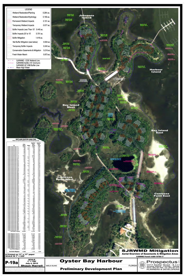 Prospectus has achieved an historic milestone with the St. John River Water Management District (SJRWMD) approval of the Environmental Resource Permit (40-089-19798-17 ) for Oyster Bay Harbours. The SJRWMD rules require a 25-foot buffer along all wetlands be kept in it natural condition. The buffer is designed to address ‘secondary and cumulative’ impacts to the wetland caused by development near the wetlands. The buffer allows existing transitional vegetation to remain undisturbed, which helps filter pollution. The continuous buffer also offers a path for critters to move and forage near the wetlands.
Unfortunately, these buffers usually don’t work well over the long run. Once residents take position of their lot, grasses planted in the backyards choke-out the transitional fauna. Residents are also reluctant to share their yard with snakes, raccoons, armadillos and similar wildlife. Often, in defiance of SJRWMD rules, fences are erected in the buffers. The fill dirt that is used to elevate the home above the floodplain often erodes into the buffer and raises their elevation. The higher rear yard also forces increased rainfall runoff into the buffers. Combining the increased runoff with erosion of fill-dirt into the buffers, impacts the transitional wetland fauna. Over the long run, these well-intentioned wetland buffers fail.
Working with SJRWMD environmental scientist, Prospectus proposed an alternative strategy. We proposed creating larger undisturbed wetland areas not located on individual lots. These larger upland pockets are permanently protected with conservation easements that are the responsibility of the homeowner association (HOA.) Removing the ownership from individuals in favor of the HOA permanently protects the habitat for wetland fauna and wildlife. Also, the larger areas are more sustainable and offer viable habitat. Once the SJRWMD was receptive to the concept, the real work started.
Prospectus compiled a detailed assessment of the area that would be created by a 25-foot buffer. Quantifying the area required by the existing rules established a baseline to compare to the final plan. The SJRWMD actual rule is: a 25-foot average wetland buffer with a minimum buffer of 15-foot along the Jurisdictional Wetland Line. We proposed to encroach within the minimum 15-foot buffer however; we would provide a ‘penalty’ for that encroachment. For every square foot of encroachment within the 15-foot minimum buffer, one and half square feet of buffer would be created. So the assessment also mandated determining the 15-foot minimum buffer areas required.
After establishing all of the required areas, Prospectus developed a master plan of the project that yielded 84-lots. We also established 31 separate Wetland Buffer areas. While the Environmental Scientist blessed the concept, the proposed conservation easements had to be approved by the SJRWMD Office of General Council. The AutoCAD file was sent to the project surveyor to create individual ‘survey maps’ and recordable instruments. James Shroads, Esq. developed and submitted ‘conservation easement’ language that would protect the wetlands. After a couple of revisions, the OGC approved the conservations easements.
The final mitigation plan approved by the SJRWMD includes a table of impacts and permanent buffers provided. Over the entire project 52,092 sf of required buffers were impact. After applying ‘one and a half to one’ penalty to the encroachments within 15-foot, the impacts were 61,781 sf. The final development plan provided 61,960 sf of ‘Buffer Mitigation Areas’ providing 9,868 sf of additional buffer than would have been created by the existing buffer rule. Overall, 227,195 sf (5.2 acres) of Conservation Easements will be recorded on the project and given to HOA to permanently manage.
They say the ‘devil is in the details’ and these are some of the most detailed plans accounting for literally every square foot of land in the project. It was really a Herculean effort however, all the work created a ‘win win’ scenario for the Oyster Bay Harbours Project and the SJRWMD. All it took was careful planning and the wisdom of SJRWMD reviewers to focus on the ‘wetland buffers rule’ original intention.
By Publisher (reprinted from searchamelia.com)
 Today I would like to welcome a new sponsor in our Search Amelia family. I have been sparring with Marc Footlik, managing partner at Oyster Bay Harbour and Yachtclub for several years on the marketing approach for this magnificent development, that once was a southern plantation with the exceptional advantage of being a water and marsh front property as well.
From the time I first set foot on Amelia Island in the mid 1990s and got introduced by Vera Boner, Ed Boner’s mother, to this resort sitting at the end of Barnwell Road, I fell in love with the opportunities of this 900 acre paradise. Vera sold my friend who was looking to move here a lot on the Municipal Golf Course however and I didn’t get re-acquainted with Oyster Bay until I had moved to Amelia Island from the Caribbean in 2006.


February 25, 2008 – Prospectus completes the designs for Crooked River Estates for presentation to the Community Planning and Development Director in Kingsland, Georgia. The community will feature 123 estate-sized lots overlooking the vast tidal marsh surrounding the Crooked River. Crooked River got its name from the river’s long, winding path to Atlantic Ocean. The master planned community features thirty lots along the riverfront that will be able to build docks. The developer, CRE, LLC, plans to excavate a large central lake offering dramatic views for the non-riverfront homes. According to project planner Shaun Harrell: “Our goal was to create a community where every lot was on the water and offered spacious views.” The community will be annexed into the City of Kingsland and connect to their sewer and water facilities. Very few communities in Kingsland will be able to offer the combination of city facilities and expansive waterfront views inside a gated community.

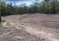
We had a pond that was going to border the rear yards of many future homes. We also had sandy, porous soils and very low groundwater conditions. The St. Johns River Water Management District rules require that bond banks be built no steeper than a 3:1 slope. There was insufficient land available to provide the required slope and reach the low ground water table. Given all these conditions, we had no choice but to construct the pond with a liner. With typical over-design, the project engineer designed the liner to have 4-foot of fill. This required over excavating pond, installing the liner and covering the liner. The removal, storage and handling of that much dirt almost doubled the projected cost of the pond construction. After a lively discussion with the engineer, and some revised calculations, the cover was reduced to two feet and construction cost were inline with the budget. These photos show the process of building the pond and it’s progression into a thriving North Florida fresh-water ecosystem.
[cycloneslider id=”protecting-trees”]
One large live oak, located in the middle of a proposed storm-water pond, had become a favorite hangout for the Roseate Spoonbills. Our original master plan sought to maximize the retention capacity of the community’s storm-water ponds. This is another example of ‘what looks good on paper, sometime isn’t.’ We worked with the consulting engineers who permitted the pond with the SJRWMD (St. Johns River Water Management District) to determine the excess retention capacity in the lake design from our master plan. We prepared a revised design that preserved the tree in the pond. Then we had to convince the developer that the extra cost of the bulkheads was warranted. Now the preserved tree offers a safe refuge for the Roseate Spoonbills during their annual summer migration and a dramatic focal point for the pond. The slide show below shows the progression of construction and the completed pond with the preserved tree. In addition to master planning services, Prospectus offers construction management which in this case took advantage of special circumstances to improve the finished product.
 December 3, 2010, Oyster Bay Harbours completes the final preparations to pave the road to the Yachtclub. The last section of road will be a dramatic round-a-bout finished with interlocking concrete pavers. Thanksgiving week workers compacted sub-grade soils in anticipation of Curb Systems, Inc. pouring curbs the following Monday. Compaction tests confirmed Tuesday that soils were compacted to 98% LBR or Limerock Bearing Ratio or better. After the tests, Malloy Grading compacted Crushcrete to provide a temporary access to the Yachtclub over the Thanksgiving holiday. Compacted curshcrete will be installed between the curbs forming the roadbed for the DOT class pavers. Tumbled Mega Oldtown pavers will sculpt the final access on to the Harbour Island Bridge.
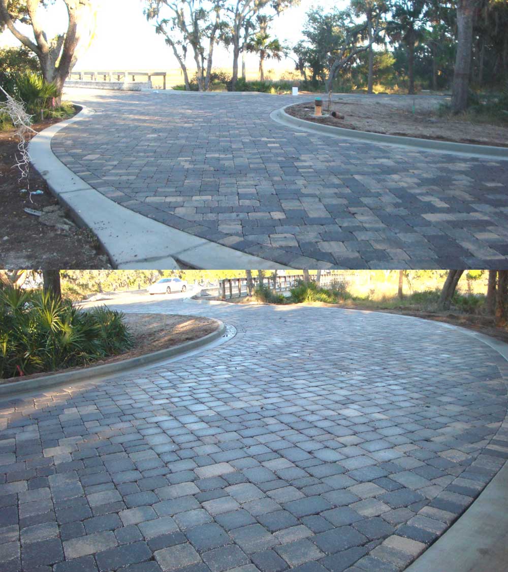 Installation of the Mega Oldtown Pavers on the round-a-bout are finished in time for Christmas festivities at the Oyster Bay Harbour Yachtclub. In spite of the chilly temperatures, Atlas Marble, Tile and Pavers installed over 6,000 square feet of pavers in less than three days. Using a crew of ten men, the job was finished in time for everyone to enjoy Christmas with the satisfaction of a job well done! Prospectus originally designed the round-a-bout and approach to the Harbour Island Bridge with the typical asphalt pavement bordered with a five-foot paver circle. “We were able to upgrade the project using DOT class pavers for the entire round-a-bout and stay within our client’s original budget,” This is a good example of delivering a superior product because we designed, permitted and budgeted the project. We knew all the constraints, upgraded the project and made our client happy.
 February 12, 2010, caught this otter feeding on the docks at Oyster Bay Harbours. He has been bringing oyster shells on to the concrete docks and smashing the shells on the dock until he can get at the meat inside. Last Saturday he was seen swimming on his back gnawing on a fish perched on his belly. Several of the docks are covered with oyster shells but not just from the otter: Sea Gulls also use the docks. They collect oyster from the beds, fly over the docks and drop them. Wonderful to see the docks put to such a “natural use.”